
Hiking is one of the most popular activities on Maui. From easy jaunts through cool Upcountry forests to strenuous treks through Haleakala’s Mars-like basin, there is a hiking trail for just about everyone. We’ve cataloged the best hikes to visit while on Maui. All of the hikes listed below are legal trails managed by the state’s Na Ala Hele system or the National Park Service. When hiking on Maui, avoid trespassing, always come prepared, and be sure to stay on the trail!

The Top 10 Hikes On Maui
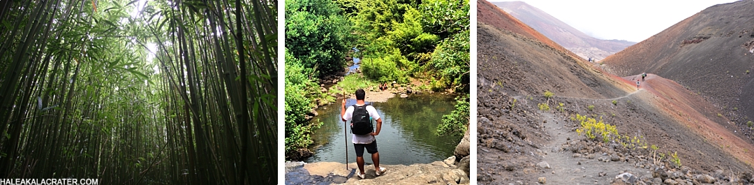
Pipiwai Trail
Waterfalls, banyan trees, and bamboo forests are the hallmarks of the Pipiwai Trail. This 3.5-mile out-and-back trail is located in the Kipahulu District of Haleakala National Park. The route travels through dense rainforest along the Pipiwai Stream and leads to the stunning 400′ Waimoku Falls. While Waimoku Falls is the decided highlight of the hike, the trail passes through an enchanting bamboo forest and travels past the 200′ Makahiku Falls overlook. The Pipiwai Trail is one of the most popular trails on Maui, so expect company on your hike.
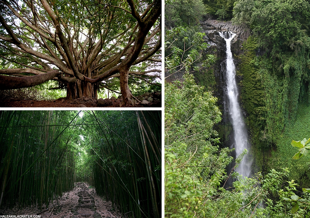
The Kipahulu District of Haleakala National Park is located near mile marker 42 on Hana Highway. The entrance fee is $30 per car. Ample parking and restrooms are available. Be sure to pack plenty of water, snacks, bug spray, and prepare to get your feet wet!
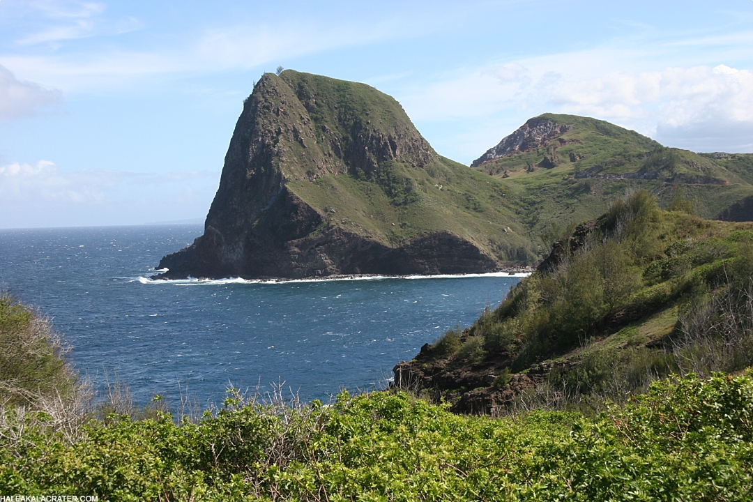
Waiheʻe Ridge
Hiking the Waiheʻe Ridge Trail is an uphill battle- literally. The Waiheʻe Ridge Trail ascends a lush windward ridge in the West Maui Mountains, overlooking Waiheʻe Valley’s verdant amphitheater. This steep trail ascends 2,000 feet in 2.5 miles for a 5-mile round trip trek. If you can brave the ultra-steep climb, you’ll be rewarded with layered views of the remote West Maui Mountains, the two-tiered Makamakaole Falls, Waiheʻe Valley, and the central and north Maui coastline. This area of the island receives a lot of rainfall, and the trail can be extremely muddy and slick. Avoid this hike if it has been raining. Hit the road early when the mountains are still clear for the best views.
The Waiheʻe Ridge Trail is a public Na Ala Hele Trail. The trailhead is located on Maluhia Road, near mile marker 6.9 on Kahekili Highway. There are two parking areas- the upper lot is closer to the trailhead and fills up fast. The lower parking lot adds additional mileage to the already strenuous hike, so get there early (gates open at 7 am) to score a parking spot. There are limited facilities at the trailhead, although there are portable toilets.
Sliding Sands Trail – Keoneheʻeheʻe Trail
DO NOT ATTEMPT THIS HIKE UNLESS YOU ARE IN PEAK PHYSICAL CONDITION! Also, make sure to bring plenty of sun protection, proper boots, poles, and plenty of water. This is a dangerous hike with loose footing.
The Sliding Sands Trail is one of the most strenuous trails on Maui and also one of the top Maui hikes. Located in Haleakala National Park’s summit district, the trek begins near the mountain’s 10,000-foot summit and descends 2,800 feet to the crater floor in under four miles. In total, Keoneheʻeheʻe Trail clocks in at 13 miles return. However, few people hike the entire route in one day. There are three backcountry cabins in Haleakala Crater that many trekkers use to break the hike into multi-day segments. These are reservations ONLY! So don’t walk in thinking they’re open to you. Most hikers choose to descend only a mile or two before turning around as the elevation, slippery sands, and steep grade make the trail extra difficult. Alternatively, hikers can connect to the Halemauʻu Trail via several junctions on the crater floor, which leads to the Halemau’u Trailhead at the park road. This route totals around 11 miles. Regardless of what route you decide to take on the Sliding Sands Trail, you’ll be surrounded by glistening silversword plants, warm-hued volcanic sands, and towering cinder cones. Be sure to assess your fitness level and pack extra water before attempting this hike.
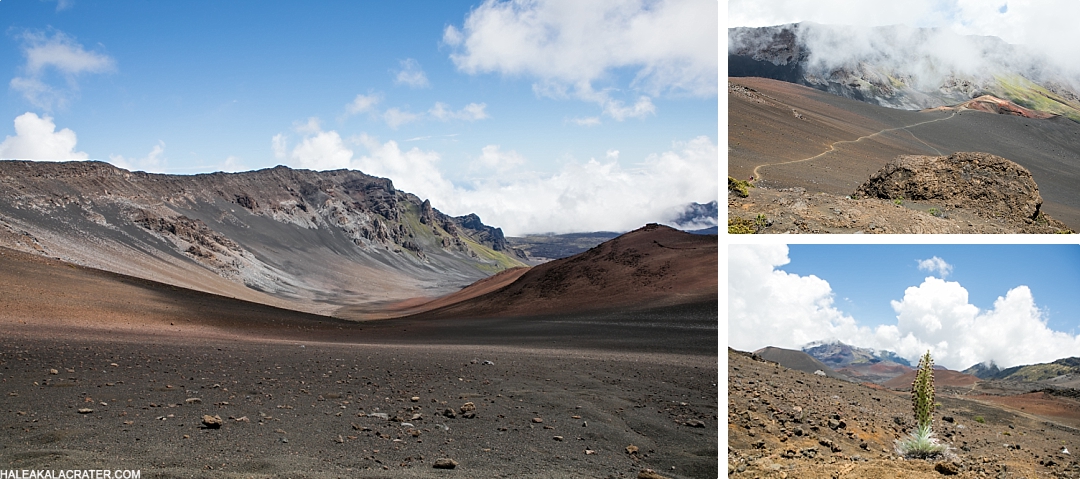
The Sliding Sands Trailhead is located on the southern edge of the parking lot near the Haleakala Summit Visitor Center- about a half-mile below the actual summit. Restrooms are available at the trailhead, but no potable water. Be sure to bring along plenty of water and sunscreen, and prepare for cold, windy weather. Reservations are required to enter the park between 3 am and 7 am.
Halemauʻu Trail
DO NOT ATTEMPT THIS HIKE UNLESS YOU ARE IN PEAK PHYSICAL CONDITION! Also, make sure to bring plenty of sun protection, proper boots, poles, and plenty of water. This is a dangerous hike with loose footing.
Also located in the summit district of Haleakala National Park, the Halemauʻu Trail totals 9.5 miles- however, like the Sliding Sands Trail, very few people hike the entirety to the trail in one go. The most popular day hike on the Halemauʻu Trail is the 7.8-mile round trip journey to Holua Cabin, which requires a descent of 2,000 feet over two miles via steep switchbacks. Despite the crushing descent, hikers are rewarded with panoramic views of lava plains on the crater floor, the gaping basin of the Koʻolau Gap, the Hana coastline, and the 8,000-foot peak of Hanakauhi. Holua Cabin is located less than a mile beyond the bottom of the switchbacks. A shorter alternative is the roughly two-mile round trip trek to “Rainbow Bridge”- where the trail travels over a narrow land bridge with sheer drops on both sides. Hikers can peer into the Koʻolau Gap and crater floor without subjecting themselves to the grueling descent on the switchbacks.


The trailhead is located off the park road between mile markers 14 and 15. Reservations are required for all park visitors entering the park between 3 am and 7 am. Be sure to wear sturdy boots. The trail is made up of gravel and loose pebbles. Expect cold, wet weather- clouds constantly filter up from the gap. Lastly, bring lots of water and sunscreen.
Hoapili Trail
The Hoapili Trail traverses the rugged lava desert created during Maui’s most recent lava flow in 1790. Another one of the top Maui hikes, many people only hike portions of this trail, but if you push through the rocky terrain, punishing heat, and lack of shade, you’ll eventually reach patches of dazzling white sand and kiawe groves at Kanaio Beach. A round trip from the trailhead at La Perouse Bay to Kanaio Beach totals six miles, but the trail continues for miles beyond that- although it is unmaintained. The Hoapili Trail is a restored portion of the historic Kings Highway, constructed in the 1500s under King Piʻilani’s reign. The route once circumnavigated the island but has been all but erased by hundreds of years of erosion. In this isolated windswept terrain, you’ll likely encounter herds of feral goats, wild views of Haleakala, and walls from ancient structures.
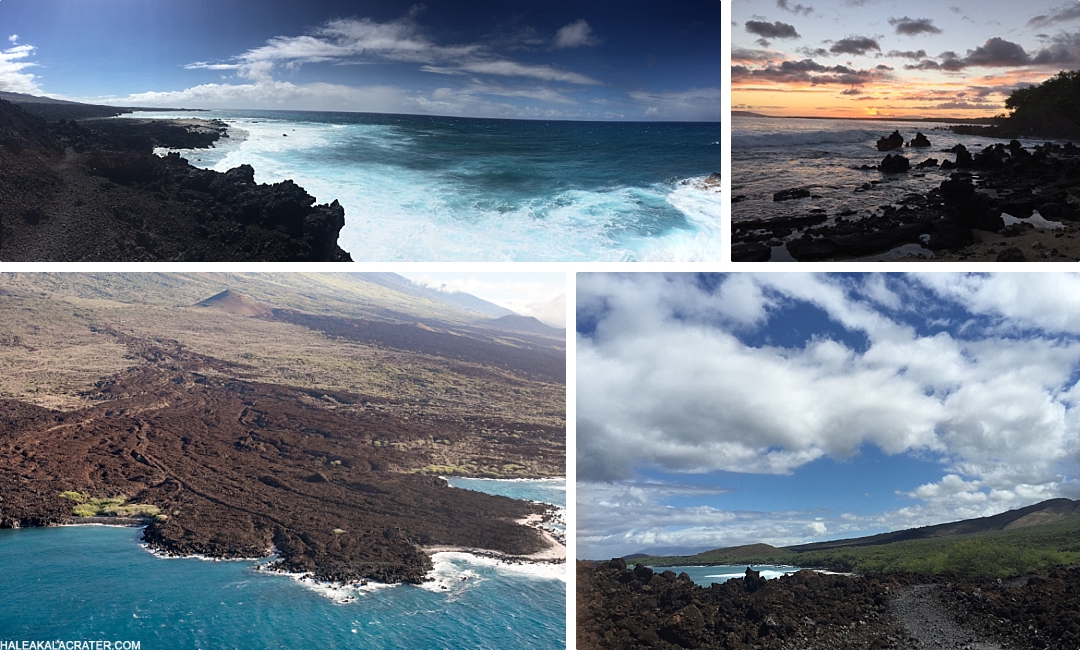
The trailhead is located at La Perouse Bay, traditionally called Keoneʻōʻio. To get here, follow Wailea Alanui Road until it turns into Makena Road. The road ends at La Perouse Bay. The Hoapili Trail is a well-marked Na Ala Hele Trail. Browse the trail information and map before starting. Lots of water, sturdy shoes and sun protection are vital.
Lahaina Pali Trail
The Lahaina Pali Trail traverses the mountains above Maui’s “Pali Highway”- the section of Honoapi’ilani Highway that winds from Ma’alaea to Papalaua Wayside Park. This strenuous trek travels to the Kaheawa wind farm and affords hikers expansive views of Haleakala, the Kihei coastline, brilliant blue seas, and the neighboring islands of Lanai and Kahoʻolawe. Intense elevation gain and harsh sun are hallmarks of this trail. However, the journey to the Kaheawa wind farm and the dazzling ocean views that go along with it are well worth it. The route travels through rocky, often dry grassland, with an elevation gain of 1,600 feet. The trail is accessible from two access points, and mileage varies depending on what route you take.
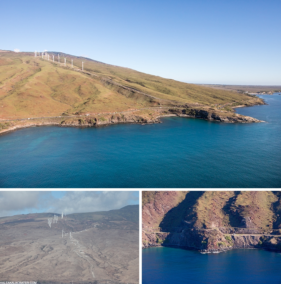
The first trailhead is located on the eastern edge of the trail, off Honoapiilani Highway near Maʻalaea. This route is 6.5 miles round trip from the 2wd parking area to the wind farm. Return the way you came. Subtract a half-mile if you have 4wd. Get an early start; the intense morning sun will be at your back. Alternatively, the western trailhead is situated near Papalaua Wayside Park. Round trip from this trailhead to the wind farm totals 4 miles. Here there is ample parking in a shaded kiawe grove and portable toilets. Water and sun protection are essential; heat exhaustion is frequent on this trail.
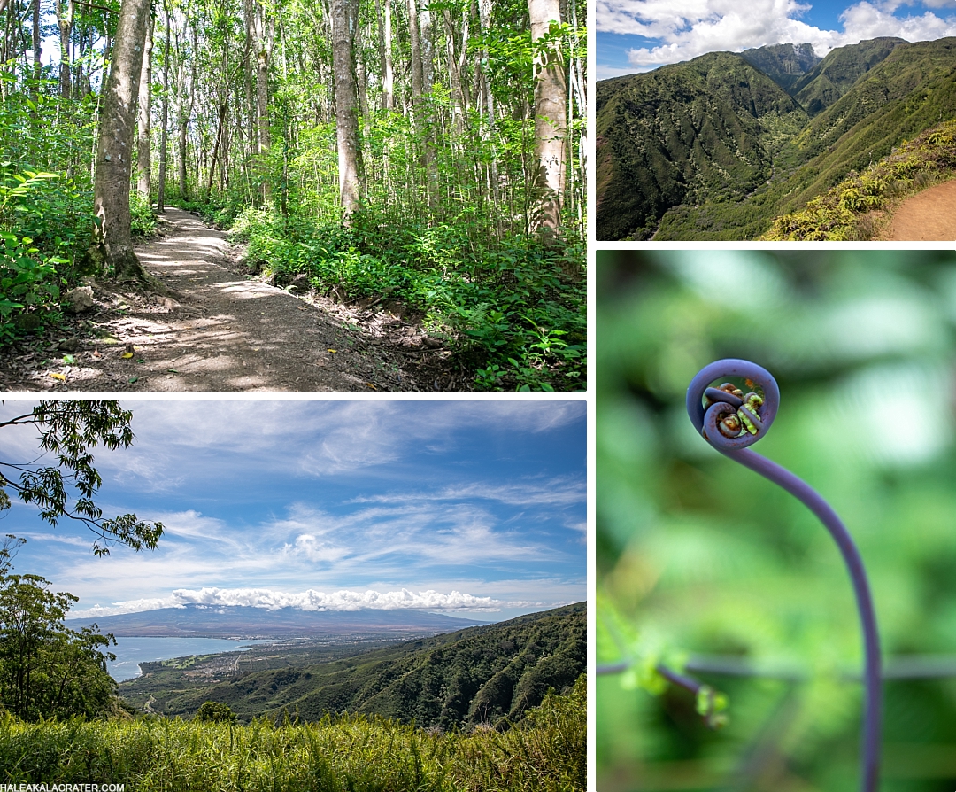
Makawao Forest Reserve – Kahakapao Loop
The lush 5.75-mile Kahakapao Loop in the Makawao Forest Reserve winds through an expanse of ferns, pines, ash trees, and native plants. With an elevation gain of 975 feet, the Kahakapao Loop is mildly strenuous. However, the elevation and the shady forest keep temperatures comfortable. The Makawao Forest Reserve is also a popular mountain biking area, and hikers share portions of the trail with bikers. The red-dirt trail is well-maintained, although it can get muddy and slick after rains.
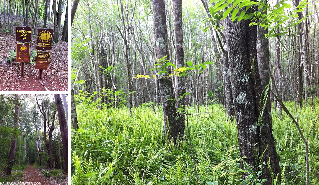
To reach the trailhead, travel 1.5 miles up Piʻiholo Road in Makawao before turning left onto Waiohiwi Road. Follow Waiohiwi Road for a half-mile, then turn right onto Kahakapao Road. The trailhead is located at the end of the road. Portable toilets are located at the trailhead. The forest reserve is open from 7 am to 7 pm daily.
Waikamoi Ridge Trail
The Waikamoi Ridge Trail is a popular stop on the Road to Hana and one of the few legal hiking trails in the area. The Waikamoi Ridge Trail is an easy 1.2 miles round trip that travels into the natural arboretum of the Waikamoi Preserve. Greenery abounds here as the trail passes through lush rainforest dotted with bamboo, ferns, and other tropical plants. Be sure to snap a picture of the unique “Quiet: Trees At Work” sign. Several viewpoints and picnic tables along the route make this short trail a great place to take a break from the long drive and stretch your legs making it one of the top Maui hikes. There is limited parking here, so be sure to park with other drivers and hikers in mind.
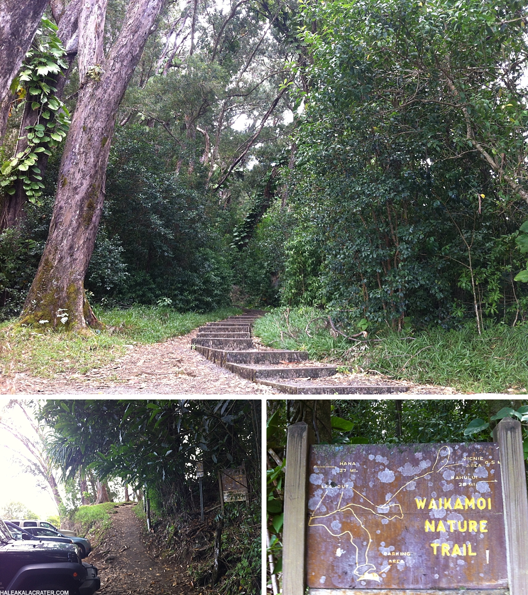
The Waikamoi Ridge Trail is located near mile marker 9.5 on Hana Highway. The parking area is on the mauka side of the road. There are no services at the trailhead.
ʻOhai Loop Trail
Situated on Maui’s northwest coast, the well-marked, pleasant 1.2 mile ʻOhai Loop Trail travels through picturesque rolling hills along a rugged cliffside. Hikers are afforded views of the lofty Kahakuloa Head and the ocean (read: wintertime whale watching). There are several benches along the way to take a rest and enjoy the view.
The ʻOhai Loop Trail sits off Honoapiilani Highway between mile markers 40 and 41. There is limited parking, spotty cell service, and no facilities in the area.
Waihou Spring Trail
The Waihou Spring Trail is an Upcountry hidden gem. Located just minutes above Makawao Town, the 2.2-mile trail is ideal for walking off breakfast from Komoda Bakery. There are two routes to choose from on this trail: the first is an easy loop that travels through the temperate forest. The other out-and-back route descends 600 feet via narrow switchbacks to a boulder-strewn ravine. The path then leads hikers to a cliffside with irrigation tunnels burrowed into the sheer wall. Locals call these tunnels the “Menehune caves,” and legends say that Menehunes (mythical Hawaiian dwarfs) once took up residence in the tunnels.
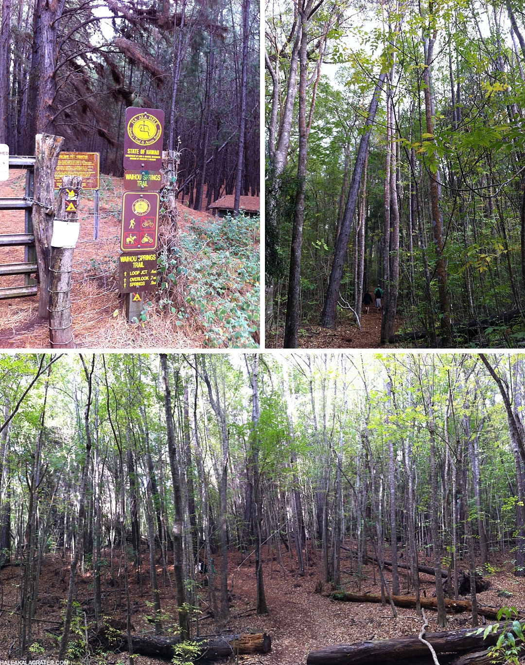
To reach the Waihou Spring Trail, follow Olinda Road from Makawao Town for about five miles. The trailhead is located just above the Maui Forest Bird Recovery Project headquarters. There is ample parking off the street, and the trail is usually quiet. Prepare for cooler temperatures and possibly some mud and rain. The trail is open from 7 am to 7 pm.